A
nalysis and Prediction of Architectural Spaces by Using Agent-Based Behavioral Systems
Keywords: Prediction space, Site analysis, Agent-Based System, Swarm behavior, Self-organization
1. Introduction
The old quarters were once the birthplace of social and economic dynamism in urban life. However, in the contemporary era, newly established urban neighborhoods lost their true purpose, and are used only as a unit of urban divisions. The main reason behind this downfall is that urban architects and designers use their personal experiences or the principles of traditional architecture in their designs, which is far from the practical reality (Ruocheng Zhang et al. 2019). Recent advances in computational design tackle the aforesaid problem and facilitate the production of new spaces as interactive spaces (Mahdiar Ghaffarian et al. 2018). CAD (Computer-Aided Design) and modern simulations have enabled urban architects and designers to design at higher levels with the help of spatial, social, and environmental simulations, and to manage infrastructure systems in a novel way. (David Gerber 2013). This work aims at using agent-based modeling and swarm intelligence (e.g., human movement simulation), to allow architects and urban designers to search for new architectural spaces based on interaction with their surroundings.
2. Research Methods
2.1. Research Process
According to Figure 1, the research process is divided into four stages: data collection and site analysis, pathology of the current situation, locating, and form-finding.

Site Analysis
Pathology
Algorithm
Final Output
Figure 1.Research steps process
2.2. Site features
The site is located in one of the old areas of the city in the east of Isfahan. In terms of neighborhood, it is adjacent to “Zayandehrood” from the south side as a main water artery of the city, “Shahrestan Bridge” as the most historical bridge from the northern side and on the other hand, adjacent to “Saruye Hill” as the most prominent and ancient place in Isfahan. The existence of these eminent spots has doubled the importance of this region.
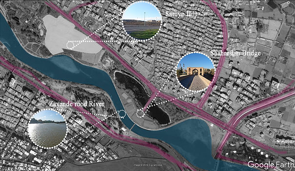
Figure 2.Site neighborhoods
This place is known as the location for holding seasonal exhibitions in Isfahan. Because of this, we have witnessed the presence of a great number of organizers and visitors who visit this place annually. On the one hand, considering the presence of people in this location permanently and the other hand, the importance of neighborhood with the above-mentioned eminent areas, the author first attempt, to analyze the current problems and secondly, achieve an appropriate substitute form.
2.3.Pathology of the current situation
At this stage, we used Pedestrian Dynamic population simulation software, which is multi-agent system software (Ma 2015), to examine the behavior of different categories of people who enter the site. We categorized the simulation result into three general groups identified by colors:
-
Blue group: People who enter the site from two sidewalks located on the north and south sides of the exhibition.
-
Red group: People who have a personal vehicle and use the entrance and exit routes leading to the area's parking lot.
-
Yellow group: People who only use the area to cross from north to south and vice versa.
-
According to Figure 3, the higher population density goes towards warmer colors which demonstrate population density during peak hours
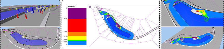
Figure 3. The first two images from the left show the scattering of people in the current space of the building on the site, which is simulated and programmed in the software. The middle image shows the behavioral analysis of the agents at different times, which according to the image at the entrance, which is also the ticket office, is purple and densely populated. The two images on the right show people's behavioral analysis at different times after different iterations.
3. Agent-Based System Tool
At this phase, we used the "Quelea" plugin to simulate agent-based algorithms. This plugin allows us to simulate complex structures, and to test and produce various forms. "Quelea" has provided a platform for Grasshopper users to simulate and analyze particle systems, agents, boards, and vehicles (Mahdiar Ghaffarian et al. 2018).
1.1 Algorithm Structure
As shown in Figure 4, the algorithm is divided into four parts:
-
Part 1: The characteristics of each group’s agents (e.g., their speed, distribution location, the environmental shape of the site, and the number of each group) are controlled.
-
Part 2: The Agent engine managed their distribution location at specific times.
-
Part 3: This step applies the internal rules between agents (i.e., separation, alignment, and cohesion), and effective forces such as wandering force to avoid a collision, contain force, and viewing angle.
-
Part 4: This step scores the resources which are influential factors in searching spaces by the agents.
-
Part 5: This step stores data to reach a three-dimensional model after finding the desired ranges and recording the movement of the agents in space.
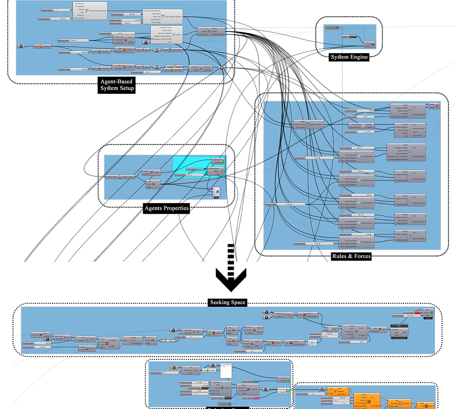
Figure 4.Grasshopper Script Process
4. RESULT AND DISCUSSION
To find the architectural spaces, we need to identify important parameters on the site and weigh them to predict the final desired points. In this site, the important parameters are divided into two sections:
-
the view and vision towards the following three particular areas: (i) the Zayanderood River in the south, (ii) the Shahrestan Bridge in the north, and (iii) the Saruye historic hills in the west.
-
the distance between agents to the entrances and exit of the site.
-
A certain weight is assigned to each area based on its characteristic and strategical position. Moreover, a range of views is assigned to each area based on the angle of human vision towards
A certain weight is assigned to each area based on its characteristic and strategical position. Moreover, a range of views is assigned to each area based on the angle of human vision towards them. Finally, by iterating the algorithm, each agent starts to search upon the indicated parameter factors. As a result, the accumulation of a set of points will emerge which represents the most appropriate spaces on the site (see Figure 5).
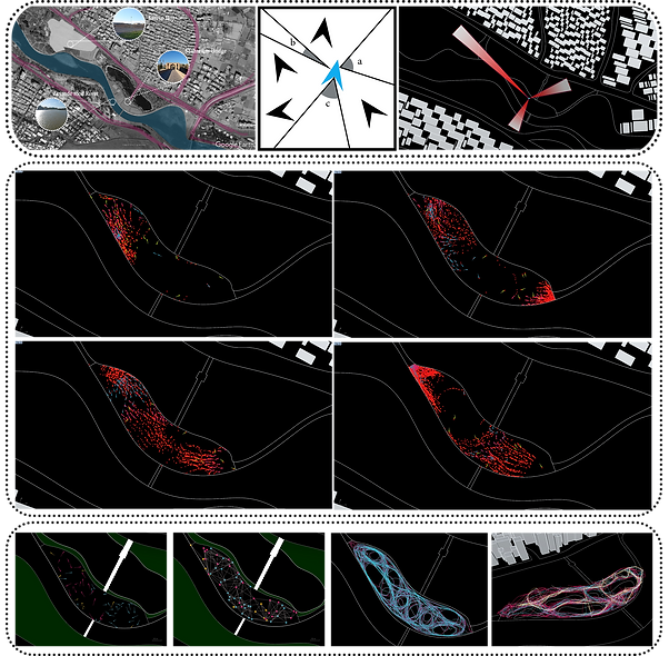
Figure 5.Agents Footprints and Circulation Pattern
In 2018, a group of researchers has used the multi-agent system in an urban environment to reach an organic and adaptive form. Moreover, the process fully produced in Rhinoceros 3d modeling software and the “Quelea” plug-in (Mahdiar Ghaffarian et al. 2018). They used negative spaces through interaction of agents with the environment for approaching organic form and considered the patterns as obstacles and attraction points from the environment. Contrarily, we tried to search and predict new spaces to achieve the appropriate form (Figure 6). Moreover, we first analyzed the pathology of the current situation and then simulated the different groups.

Figure 6.Generation Architectural 3D Form
5. Conclusions
Swarm intelligence assists architects to design a process that is more adaptive to the environment instead of creating a form. In terms of the potentials obtained in this research, this path can be used to promote the revitalization of an area as a study tool as well as a feature to decide how to arrange different spaces in each environment. Moreover, the core of this model can be expanded by appending advanced scripts. For instance, Machine learning scripts can add a new feature to agents to use their previous experience in the new and subsequent locations which will help to solve problems more accurately.
5. References
-
David Gerber, R. S. (2013). CONTEXT-AWARE MULTI-AGENT SYSTEMS NEGOTIATING INTENSIVE FIELDS. The 2013 Association of Computer-Aided Design of Architecture (ACADIA) (p. 10). Los Angeles, CA, USA: Association of Computer-Aided Design of Architecture (ACADIA).
-
Ma, W. a. (2015). Pedestrian dynamics in a real and simulated world. Journal of Urban Planning and Development, 141(3).
-
Mahdiar Ghaffarian, R. F. (2018). Organic Architectural Spatial Design Driven by Agent-Based Crowd Simulation. Proceedings of the Symposium on Simulation for Architecture and Urban Design (p. 8). Delft, the Netherlands: SIMAUD '18: Proceedings of the Symposium on Simulation for Architecture and Urban Design.
-
Ruocheng Zhang, H. T. (2019). "A GENERATIVE DESIGN METHOD FOR THE FUNCTIONAL LAYOUT OF TOWN PLANNING BASED ON MULTI-AGENT". 24th Annual Conference of the Association for Computer-Aided Architectural Design Research in Asia, April 2019 (pp. 231-240). Wellington, New Zealand: Association for Computer-Aided Architectural Design Research in Asia (CAADRIA).